Field Trip 05A: Short Course and Field Trip – CANCELLED
Field Trip 05B: Short Course only – CONFIRMED
Advances in Drift Prospecting for Kimberlite in Canada
Leaders: David Sacco (Principal, Surficial Geology and Exploration, Palmer)
Dave Sacco graduated from Simon Fraser University in Vancouver, Canada and is well known in the North American kimberlite exploration community for his specialization in the application of Quaternary geology to mineral exploration. He has 15 years’ experience in the industry and has spent over 10 years applying his trade to diamond exploration in Canada. Dave is a recognized authority in defining the glacial dispersion of kimberlite indicator minerals and identifying their kimberlite source through the development of customized drift prospecting strategies. He has published numerous surficial geology and sampling suitability maps and reports that showcase the utility of drift prospecting and provide the foundation to optimize diamond exploration programmes.
Dave’s recent emphasis on developing more reliable methods for exploring in complex surficial environments, where standard approaches can be ineffective, provides a crucial exploration tool for establishing reliable kimberlite targets and mitigating project risk. Dave has been a lead researcher for surficial exploration programmes supported by Geoscience BC, the British Columbia Geological Survey, the Alberta Geological Survey and the Northwest Territories Geological Survey. His comprehensive expertise has played a vital role in “30 Years of Diamonds in Canada” which is being celebrated at 12 IKC. During this event, Dave not only leads this field trip and short course, but also serves as the primary or co-author of six presentations in the Technical Programme. These presentations cover various aspects of the Evolution of Kimberlite Exploration, including Advances in Drift Prospecting in Canada’s North and Kimberlite Indicator Mineral Dispersion on the Kennady North Project, Southern Slave Craton, NWT.
Dates:
CONFIRMED The post-conference, half day short course will take place on the afternoon of Saturday 13 July 2024.
CANCELLED The field-based part will take place on Sunday 14 July 2024 (full day).
Duration: Half day.
Location: The short course will be in Yellowknife.
Registration: The cost of FT05B which includes only the short course will cost $175 CAD and does not include accommodations or transport. SeeField Trip Overview, Important DatesandRegistrationfor more details.
Accommodation: To be organised by delegate. The 12 IKC preferred room rates at the three hotels are available for the dates required to participate in FT05A and FT05B so bookings for the main conference can be extended. See Accommodation Page for more details.
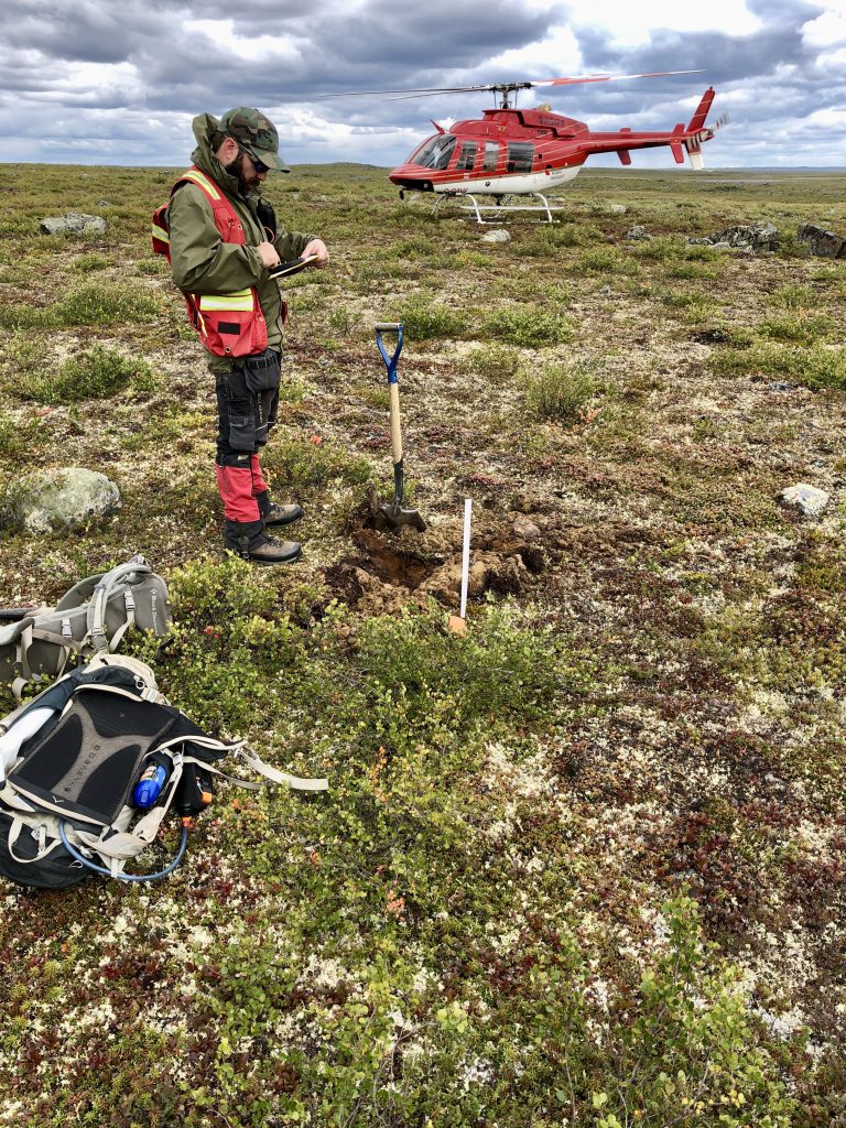
Description: Join renowned expert Dave Sacco for a deep dive into drift prospecting for kimberlite (and other commodities!) in Canada. Drift prospecting is the science of tracing surface sediments back to their bedrock source, which in Canada, requires a detailed understanding of glacial geomorphology and landscape evolution.
The short course will provide a foundational understanding of glacial processes and how sediments are created and distributed throughout the landscape by tracing the path from mechanical erosion and glacial entrainment, through primary deposition of till, and subsequent modification and remobilization by deglacial meltwater processes. The effects of these processes on the sediment composition, and ultimately indicator mineral and geochemical concentrations will be demonstrated through a series of case studies. We will discuss how these landforms are identified remotely, and finally, how this information can be used to design and execute successful drift prospecting programmes and evaluate the resulting data within the appropriate glacial context to generate exploration targets.
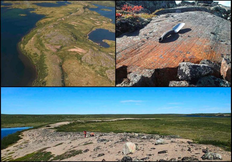
Top Left – Aerial view of a meltwater corridor in the Slave Geological Province. Top Right – Glacial striations in outcrop. Bottom – Ground view of an esker armoured with boulders from wave-washing in a glacial lake.
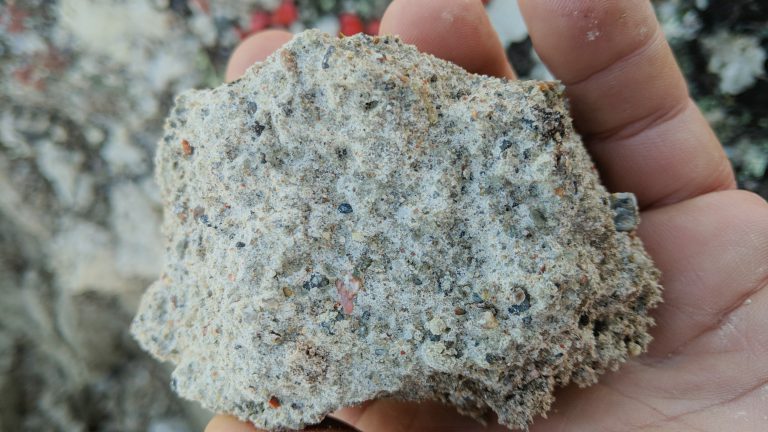
Close-up image of subglacial till, the optimal media for drift prospecting.
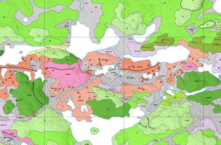
An example of detailed surficial geology mapping, which is used to inform drift prospecting programmes.
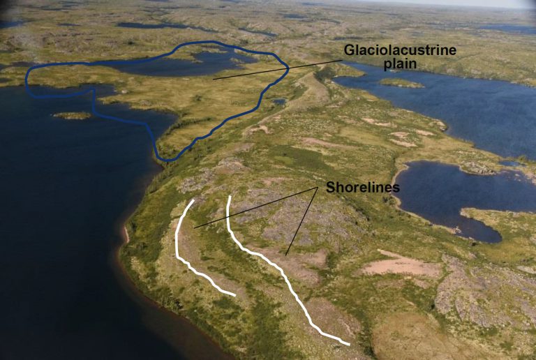
Glacial and Post-Glacial features visible in modern landforms
Kimberlite indicator mineral (kim’s) dispersal trains in a complex surficial geological environment.